Celebrating Our Fifth Consecutive GovTech 100 Win
We are thrilled to announce that we have been named to the GovTech 100 list

Geolocation data is an important source of real-world context and insights for many industry verticals. GPS tends to be the dominant source of geolocation data by volume. Our blog post this week revisits the fundamentals of GPS location precision and accuracy ensure the best return for your location data investment.
What is a Location Data Point ?
A location data point is a sequence of numbers that represents the geo-coordinates [ latitude and longitude ] for a point on the map. As an example, the location data point for CITYDATA's office in the City of San Francisco is represented as:
CITYDATA
548 Market Street, San Francisco
[ 37.78991, -122.40080 ]

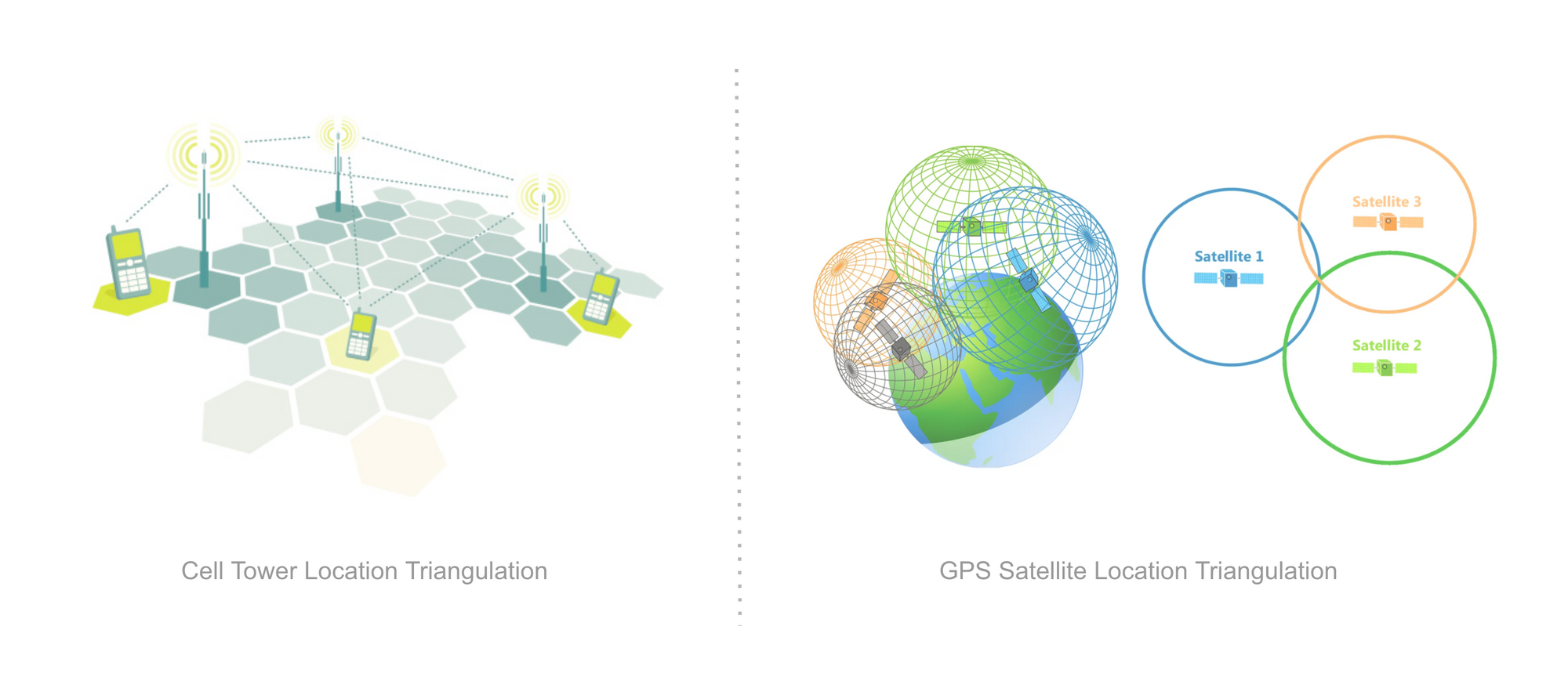
GPS Location versus Cell Tower Location
GPS location is derived from the constellation of satellites that power the location technology in smartphones, IoT sensors, cars, planes, drones, and basically anything that moves in the real world. Location can also be derived from telco cellular towers, but such location tends to be significantly less accurate that GPS derived location. To learn more about the difference between GPS and cellular data, please read our related blog post here.
Aren't precision and accuracy the same?
We've all heard that location data needs to be both accurate and precise in order to be actionable. What that does that really mean? Are the terms precision and accuracy interchangeable? The answer is "no".
CITYDATA.ai has put together this cheat sheet to unravel the mysteries of location accuracy and precision, for the benefit of everyone in the industry.
How "Precise" are GPS location signals?
Precision indicates the exactness of the location signal. The precision of the raw latitude and longitude is represented by the number of digits after the decimal point, ranging from 1 to 9. The table below lists the precision levels and explains the significance of each digit.
| Decimal Place | Queen's Distance | American Distance | Translation |
| 1 | 10 kilometers | 6.2 miles | Town or City |
| 2 | 1 kilometer | 0.62 miles | Neighborhood |
| 3 | 100 meters | 328 feet | City Block or Park |
| 4 | 10 meters | 33 feet | Street Address |
| 5 | 1 meter | 3 feet | Store Entrance |
| 6 | 10 centimeters | 4 inches | Drone Control |
| 7 | 1 centimeter | 1/2 an inch | Military Operations |
| 8 | 1 millimeter | Paper Clip | Civil Engineering |
| 9 | 0.1 millimeter | Strand of Hair | Likely fake data |
When evaluating sources of location signals, it is important to verify the precision of the dataset to ensure that latitude and longitude values include at least 4 digits after the decimal point. In other words, the signals should be precise to at least 10 meters or 33 feet for the location dataset to be useful for mobility, transportation, urban planning, and smart city use cases.
How "Accurate" are GPS location signals ?
Accuracy indicates conformance with reality. Represented by a 2 digit number measured in meters, accuracy is the error margin in the reported latitude and longitude values relative to the ground truth. Most smartphone GPS receivers have an accuracy of 5 meters or approximately 15 feet. However the accuracy could worsen near buildings, structures, trees, or indoors. Accuracy could also fluctuate with cloud cover and weather conditions.
Accuracy can be horizontal or vertical. The accuracy reported in location datasets is almost always the horizontal accuracy. GPS receivers in mobile phones are not designed to capture vertical accuracy beyond 5 meters, rendering such measurement moot in dense urban or downtown settings.
It is not uncommon to see location datasets with accuracy ranging from 1 meter to 25 meters. Below is the horizontal accuracy distribution for one of our location datasets comprised of approximately 2 billion location signals obtained from 20 million mobile devices in a US city.
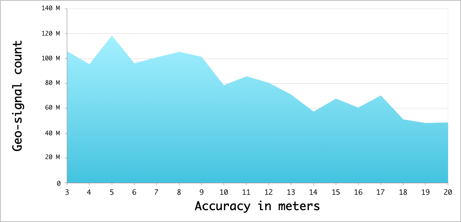
When considering location datasets, it is important to understand the accuracy distribution of geo-signals to ensure that the bulk of the data has an accuracy better than or equal to 10 meters. Any more that 20 meters would be unacceptable for deriving actionable intelligence and meaningful geo-insights from your data.
Evaluating your location datasets
CITYDATA.ai has evolved a sophisticated set of tools and techniques for rapid analysis of large location datasets with trillions of data points. Reach out to us if you'd like us to evaluate your location data and provide a summary report for free.