When the going gets tough, Camels outlast Unicorns
The Bactrian Camel isn't pretty to the conventional eye. With two oddly large
This blog post delves into the relevance of GPS-based mobility datasets sourced from telecommunications carriers and mobile operators for solving real-world problems.
Sign up for our webinars to learn from our data scientists and geospatial experts. They will show you how geospatial intelligence can be used in the most cost-effective way to measure and analyze movement patterns.
CITYDATA crowdsources fresh accurate and anonymized GPS data from mobile apps and publishers around the world. Our data is curated with the highest attention to consumer privacy and regional regulatory compliance. While we consider ourselves to be one of the largest independent unaffiliated datasets for mobility data, in some regions we are starting to see the benefits of combining our data with telecommunications carriers and mobile operators.
Telcos are the largest holders of local data in every country. The sheer volume of their massive datasets makes the term "big data" feel insignificant. However, telco cellular data does have two main challenges:
Most countries host 3 or more telcos that provide voice and data services. On average, a dominant telco might represent 30% of the resident population. Rarely does a single telco exceed 40% of the population coverage.
Telcos operate networks comprised of cellular towers. The towers are installed in urban areas using well-established network spacing patterns based on population density to optimized coverage.
Data collected from cellular networks like 3.5G and 4G historically has had an accuracy of 1500 feet to 3000 feet or roughly 500 meters to 1 kilometer. In the most likely scenario, data from a cell tower could be used to triangulate a device or a person to within 2000 feet of where they really were located. This makes it nearly impossible to derive meaningful inferences.
Another glaring drawback of cellular technology is its geographical coverage. Cell towers are densely packed in urban areas because of higher revenue potential for the telcos. For subscribers in rural areas or people who travel away from home, cellular networks are not always a reliable ally.
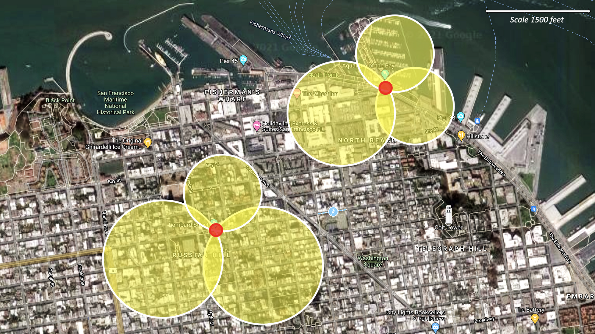
In the below map, relying on data from a single cellular tower would indicate that the person is near Fisherman's Wharf in San Francisco. However, the signal accuracy of 1500 feet could mean that the person might be boating in the bay, or strolling through the piers, or working at the corporate offices, or lunching at a waterfront restaurant, all within 1500 feet. It is possible to triangulate the position of a device with improved accuracy if the device is picked up by 3 or more cell towers as highlighted by the intersecting yellow circles on the map. However, such triangulation requires more effort on part of the telco.
The Global Positioning System or GPS is a government-owned navigation system structured by about 32 solar-powered satellites that orbit around the Earth. The main idea of GPS systems is to determine the location of a certain object or person in real time. GPS tracking systems utilize the global navigation satellite system (GNSS) network. Each of these satellites in orbit sends microwave signals to a receiver in the mobile phone. Precise location is calculated using signals from at least four GPS satellites by applying a mathematical process called trilateration.
The location accuracy of GPS data ranges from 10 feet to 300 feet. The average GPS accuracy is within 15 feet. This makes is attractive, beneficial, and relevant for telcos to collect GPS data from their subscriber's mobile phones, with full disclosure and consent. However, few telcos take the effort to do so. Some telcos are starting to embed GPS data collection SDKs (software development kits) within the preloaded mobile apps like customer service and support apps, entertainment apps, and weather apps. The value to the end users is a contextual and customized mobile experience based on their location. Users of course can choose not to share data with the telcos by denying permission.
The main drawback of GPS is that it requires line of sight. When the skies are cloudy, so is GPS. Objects such as mountains, clouds, buildings and trees might interfere with a successful GPS connection. Without a clear view of the sky, atmospheric interference makes locating users more difficult. That’s also why locating people in buildings can be ineffective with GPS.
Telcos have the unique advantage of being able to collect cellular, GPS and WiFi data. The mobility data collected by telcos can be used to enable a variety of real-world use cases across different verticals:
With the exception of marketing and advertising, most of the use cases do not require device-level data or personally identifiable information (PII). In other words, the data can be fully anonymized and aggregated by the telcos thereby making these use cases compliant with local and regional privacy regulations.
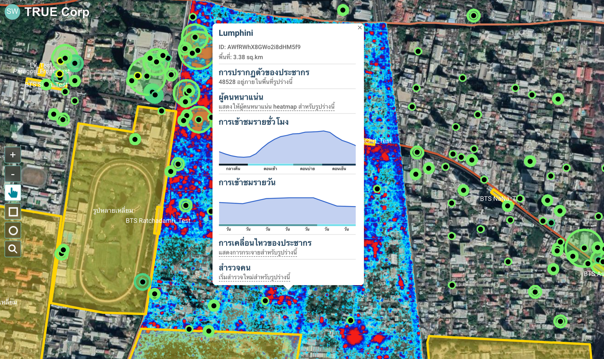
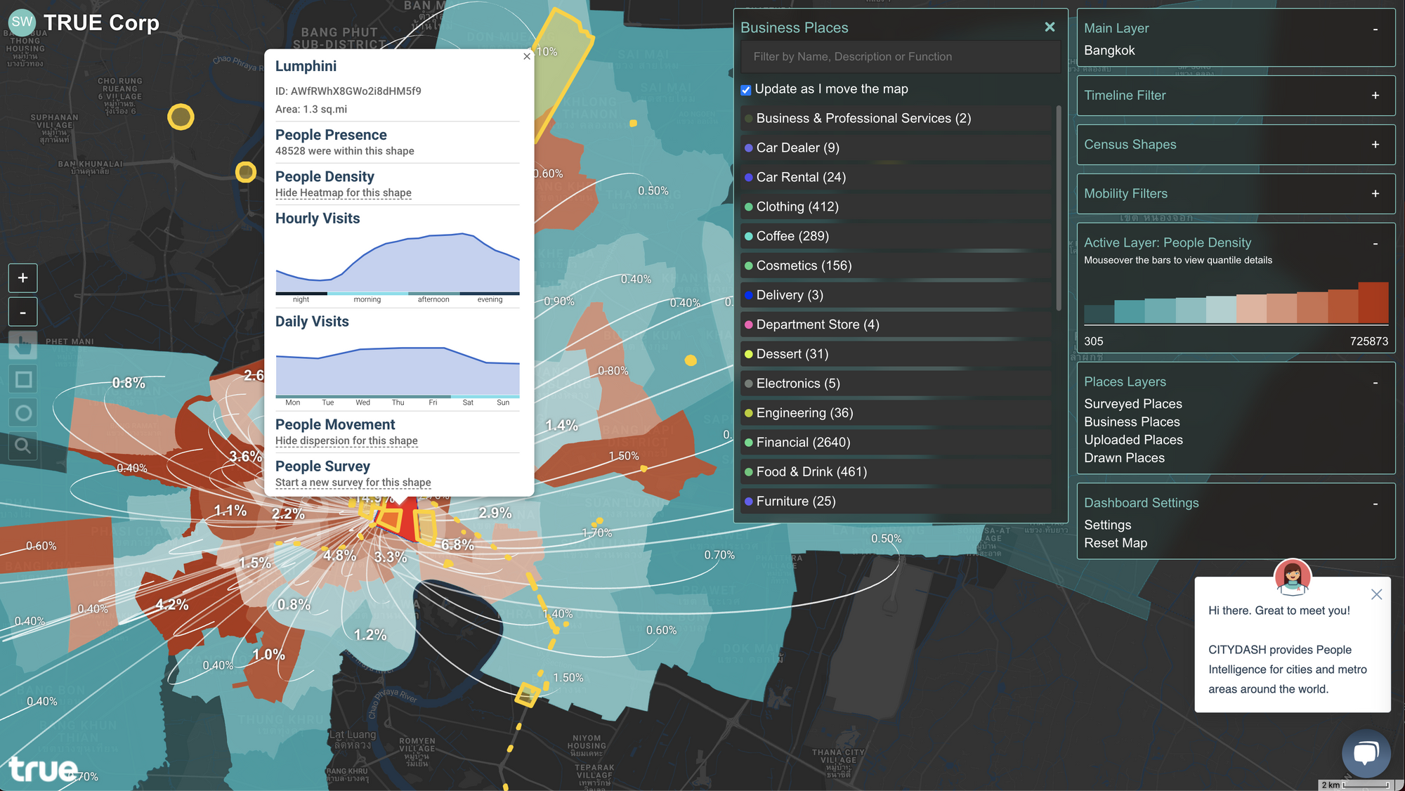
In Thailand, CITYDATA has partnered with TRUE Corporation, one of the largest telcos in the region. The partnership enables CITYDATA to curate GPS and WiFi data points from TRUE's subscriber base with full disclosure, consent and opt-in by end users. Our CITYDASH platform enables geospatial AI patterns, trends, and visualizations for TRUE and their downstream customers. Such GPS data combined with cellular data provides TRUE with the business intelligence to enable monetization through a wide range of use cases.
Telcos can augment their cellular data with GPS data and WiFi data to create monetizable data assets across different verticals. CITYDATA can jump-start new revenue streams for telcos. Reach out to us if you'd like to learn more about how you can partner with CITYDATA to infer people-density, mobility patterns, trip hops, place visit trends, audience segmetns and geo-behaviors by applying geospatial AI to blended mobility datasets.
CITYDATA.ai provides pattern-of-life mobility data + Ai for smart cities. CITYDATA knows the answers to the questions “how many people are in your city today” and “what are their movement patterns?”.
CITYDATA offers five main data-as-a-service products:
Founded in 2020 in San Francisco, California, CITYDATA provides fresh, accurate, daily insights that are essential for smart city programs, economic development, urban planning, mobility and transportation, tourism, disaster impact analysis, sustainability and resilience.
You can reach the company via email at business@citydata.ai if you’d like to discuss your data needs and use cases. You can also follow the company on Linkedin, Twitter, Facebook, YouTube, and the UniverCity.ai blog to stay updated on the newest innovations in mobility data + Ai.