When the going gets tough, Camels outlast Unicorns
The Bactrian Camel isn't pretty to the conventional eye. With two oddly large
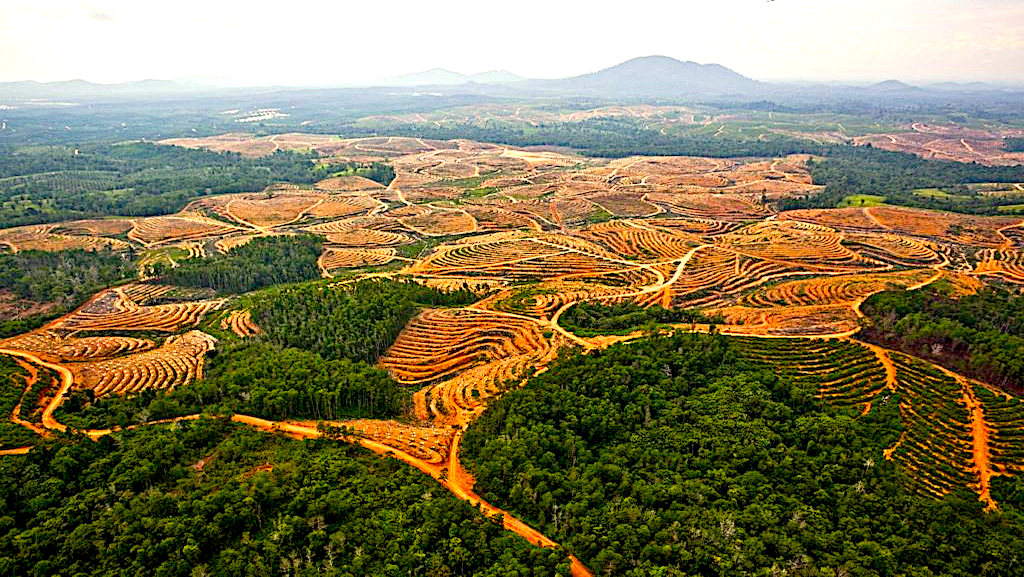
This blog post and case study, authored by our partner Earthqualizer, discusses the usage of geospatial data and machine learning for tracking, protecting, and reversing the impact of palm oil deforestation in Riau (Indonesia), North Sumatra (Indonesia), and Sabah (Malaysia) in Southeast Asia.
Sign up for our webinars to learn from our data scientists and geospatial experts. They will show you how geospatial intelligence can be used in the most cost-effective way to measure and analyze mobility data.
Palm oil is one of the main contributors to deforestation through the conversion of forests and peatlands into plantation areas. For approximately a decade, efforts have been made by various parties to reduce the impact of forest and peat destruction, including the adoption of the "No Deforestation, No Peat, No Exploitation" (NDPE) policies. These policies were started by Nestle in 2010 and were later widely followed by other industries including Wilmar in 2013. Currently, more than 80% of global palm oil traders and refiners have adopted the NDPE policies.
The Earthqualizer Foundation is a non-profit organization, dedicated to transforming the supply-chain of agricultural commodities for the benefit of people and nature. A spin-off from the Aidenvironment Foundation in the Netherlands, Earthqualizer has been active in Indonesia and Southeast Asia since 2009. Together with corporate partners, Earthqualizer deploys the Supplier Group Monitoring Program (SGMP), a risk management tool that screens and monitors palm oil traders’ compliance with the NDPE policies. SGMP is widely recognized as a risk assessment tool that delivers credible and actionable supplier compliance data.
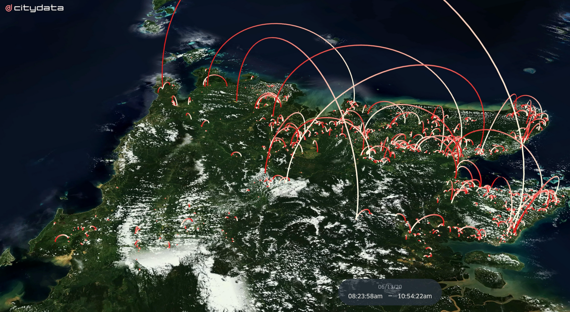
To solve the palm traceability challenge, Earthqualizer collaborated with CITYDATA.ai and Cube Eye to conduct an in-depth analysis in Sabah (Malaysia), Riau (Indonesia), and North Sumatra (Indonesia) to monitor the trend in supply movement from plantations to mills and forests. The tri-party alliance analyzed fresh, accurate, anonymized and crowdsourced geo-location mobility data and applied machine learning to identify the heretofore unknown relationship between the non-compliance in oil palm development (upstream) and its buyers (downstream).
"Using high-quality curated geospatial datasets from CITYDATA for movement analysis, we were able to uncover deep insights about the supply chain operating in the forests in Southeast Asia," said Ihwan Rafina from the Earthqualizer Foundation.
From January 2016 to December 2020, Earthqualizer traced and mapped out the conversion of forest and peat to oil palm plantations for 5980 square kilometers (2309 square miles) in Indonesia, Malaysia, and Papua New Guinea. The findings highlighted that approximately 26% of the deforestation occurred in the company areas without known supply-chain information (orphan cases) which typically results in produce getting routed to the global NDPE market (leakage market). Orphan cases are a major concern for the stakeholders in the sustainable palm oil industry and a level playing field should be encouraged to address this. To this end, Earthqualizer has provided insight and assistance for partners to check for the presence of orphan cases in their supply chains.
"Earthqualizer believes in a sustainable world where economic success is based on respect for people and nature. We are thankful for the opportunity to bring our geospatial datasets and machine learning expertise to help make natural resource-based industries more accountable and sustainable," said Apurva Kumar, CEO of CITYDATA.ai
The geospatial data and mobility patterns across the deforestation areas, palm oil concessions, mills, and refinery facilities, revealed that at least 2 orphan deforestation cases are linked to a large palm oil producer in Sabah and 26 deforestation cases are linked to major palm oil mills in Riau and North Sumatra. This data is in line with the findings from other NGOs that have exposed the presence of deforesting companies in well-known palm oil mills and palm oil traders, despite making commitments to the NDPE principles.
Earthqualizer's data-driven research, analysis, and key findings are intended to encourage transparency in the implementation of NDPE and illustrates the importance of mapping the overall NDPE responsibility of the palm oil industry from upstream components to downstream entities using credible data and geospatial AI.
CITYDATA.ai provides pattern-of-life mobility data + Ai for smart cities. CITYDATA knows the answers to the questions “how many people are in your city today” and “what are their movement patterns?”.
CITYDATA offers five main data-as-a-service products:
Founded in 2020 in San Francisco, California, CITYDATA provides fresh, accurate, daily insights that are essential for smart city programs, economic development, urban planning, mobility and transportation, tourism, disaster impact analysis, sustainability and resilience.
You can reach the company via email at business@citydata.ai if you’d like to discuss your data needs and use cases. You can also follow the company on Linkedin, Twitter, Facebook, YouTube, and the UniverCity.ai blog to stay updated on the newest innovations in mobility data + Ai.